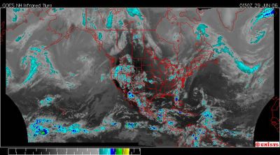
June 29, 2006. 0130z.
UNISYS Enhanced Infrared Satellite - Hemispheric.
I'm going to put a dialogue to this image. Take a good look at it. Come to your own conclusion and then we'll see if we agree. I already know I am right, but, I keep an open mind.
Ready.
I usually take the time to allow my mind to fill with the image enough to draw on it's own memory to impose difference from the past. It's a tedious exercise I put myself through. I could compare satellite images with other satellite images but I work completely from memory. I trust my mind.
I already know people are going say, this broad is off the wall. Not so.
Confusing looking image, isn't it? I agree. Let's break it down.
Where is the light part of the image?
Where is the dark?
The 'light' cloud cover type of color is exclusively in the north. Yes, it is. There is no 'color' that matches anything in the south that is in the north. Don't believe me to believe me. Decide. Color, intensity, pattern, DIVISION.
See, it yet?
Now. Let's look at the north. I'd like to say it is all due to 'the jet stream.' Would I love to say that and never have to look another satellite image again. But, it isn't. There are vortices at every 'scallop.'
I am not going to explain the dynamics of vortices. Just recall that most of the 'water' is in the north. Leave it there. Tuck it under your pillow. You might want to ask, what it is doing there.
Okay.
The southern aspect of the picture.
Take a good look.
It's void of water. Isn't it? Compared to the north. It's mostly void of water.
Except for where?
Where? The coastlines of the North American Continent. Yes? Yes.
Why? Hm. Coastlines. Water at the coastlines. Cooler water than the continent. Hm. Turbulent air. Yep. Storms.
But, what about the center of the continent? What gives?
Drought. Simple as that. All the water is in the north spinning around the Arctic Circle. There is precious little water over the continent because it's hot. The terra firma of the USA is hot. Carbon dioxide blankets this nation and the heat intensity has grown so much that it has no dew point at ground level. The water 'vapor' in the troposphere over the continent evaporates before it ever hits the ground.
So what is that line across the bottom. That's turbulent, too. There is water there. What is that all about?
Hm. The equatorial air. Oh, that. Well. Take a good look. Where is the land along that line? The North American continent where it approaches South America. There is only a tiny piece of land to interfer with the equatorial air and it's travel around Earth. That air mass at the equator is probably the most 'healthy' aspect of the picture. At least for now.Try to imagine where the 'solar rays' are hitting. Then come to understand they are far from the equator. Just south of the equator is a huge rainforest. The Amazon. The beautiful and ever endangered Amazon. It absorbs carbon dioxide in huge amounts whenever the sun is up. It also provides moisture to the air. So there is an equatorial dynamics that plays out separately from that above the Tropic of Cancer. The Tropic of Cancer is 23.5 degrees north (click on).
But there is one other aspect to this.
The curve of Earth. You all know about curves. Women worry about them. Men adore them. Well. Earth's curves aren't quite that enticing. But it exists doesn't it? In that 'click on' map, Earth is curved. The way inwhich the solar rays hits Earth depends on it's angle, rotation and curve at any one location on this planet in it's relentless travel around Sol providing a benevolent biota in a very hostile universe.
Do me a favor. Learn to love Earth. It loves you. Let's get this stuff right. With any luck, the lives we save will appreciate the fact they were saved and will want to do the same to the planet that sustains them.
Shalom.
I really don't give a hoot about what Anderson has to say for the rest of the next hour or the one that just transpired. He has no 'agenda' of benevolence and seeks to back a president intent on 'burning the house down' including the planet that loves us.